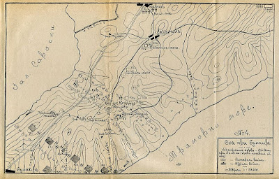
With the Mediterreanan Fleet in Constantinople, it was essential that Britain secure the Dardanelles to prevent them becoming trapped as the Russians advanced. The Russians had not yet occupied this part of European Turkey yet, and so the British would hope that a swift amphibuous landing could capture the penisula before they arrived.
Some Ottoman soldiers would be in the area, but these would either be second rate irregulars or garrison troops. Unlike in 1915, this would essentially be a meeting engagement on land, rather than an opposed amphibious assault. The Gallipoli penisula is narrow, and so there will not be many map moves, whilst the small size of the opposing forces should still allow for mobile battles.
So, in the blazing heat of a Medieterreanan summer, the first clash between the British lion and the Russian bear takes place.
The events of 1915 mean that there are plenty of maps of the Gallipoli penisula around. Mostly, though, these are of the beaches to the east, which are unlikely to feature in the campaign. Great War maps also show the positions of the Turkish shore defences. These were far more extensive in 1915 than they were in 1878, but the major forts didn't move.
Rather more usefully, there was the Battle at Bulair in 1913. Bulair is the Bulgarian name for the town of Bolayir. The Bulgarians won the battle, hence they got to name it. Bolayir/Bulair is the key to the pennsula, and it the village in the top right of the map shown. the map below shows the 1913 battlefield. I see no reason to think it was substantially different in 1878.
A joint British and French force landed in Galliopli during the Crimean War as well. The remains of the earthworks they dug still showed on later maps. Restablishing this would probably also be a priority in 1878. You can see it just to the southwest of Bolayir on this map.
Bolayir will most likely be the scene of the action. However, the British will probably want a beachhead further west, and the Russians will be advancing from the east. This map shows more detail of the whole theatre, including Constantinople, where the Royal Navy is.
This map, meanwhile, shows the possible landing areas on the penisula.
Finally, whether it is the initial landing point or not, the British will want to use the port of Gallipoli, so here is a more detailed map. It is the same scale as the Bolayir map.
Looking at those maps you may well be wondering how high thse hills are. The answer is, not that high at all. This, for example, is the view today looking Southwest from Bolayir. The rolling hills provide a vantage point for observation, but wouldn't be a huge obstacle to manoevre.


No comments:
Post a Comment